| ASN-104/105 Unmanned Reconnaissance Aerial Vehicle
中国ASN-104/105型无人机 Date:2010-02-06 Source:internet By:globalmil Viewed: |
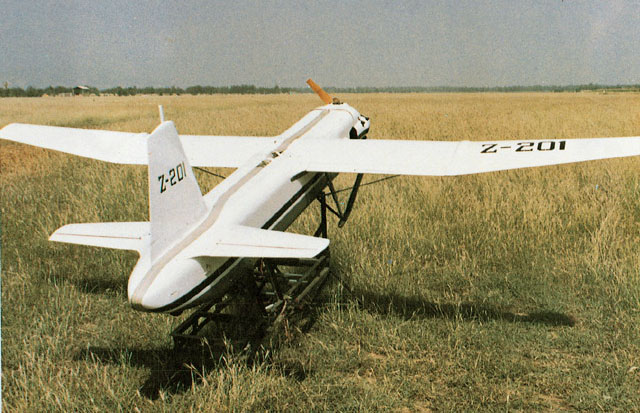
ASN-104 (D-4) unmanned aerial vehicle (Chinese Internet).
ASN-104型(D-4)无人机(中国英特网)
The ASN-104 (also known as D-4) tactical unmanned reconnaissance aerial vehicle (URAV) was developed by Xi'an ASN Technology Group Company, a commercial company of the Northwest Polytechnic University (NPU) in early 1980s. The ASN-105 is an improved variant introduced in the early 1990s. The ASN-104/105 was the first generation indigenous tactical URAV in service with the PLA, designed for battlefield reconnaissance, day/night surveillance, border patrol, artillery spotting, and aerial photography and prospecting roles.
ASN-104型(也即是D-4型)战术无人侦察机(URAV)由西安爱生技术集团公司发展,1980年早期西北理工大学(NPU)成立的一家商业公司。ASN-105型是一种在1990年早期推出的改进型。ASN-104/105型是在PLA服役的第一代国产战术无人侦察机(URAV),设计用于战场侦察、昼/夜监视、边境巡逻、火炮(落弹)观测、航空摄影和探矿任务。
Programme
NPU began to develop a lightweight tactical battlefield surveillance UAV in the early 1980s. The resulted D-4 (ASN-104) made its first flight in October 1983 and entered batch production in 1985. The D-4 was designed for military reconnaissance and civil aerial photographic survey. The onboard optical and night vision cameras can provide real-time TV images of the battlefield within 60km range. The ASN-105 was developed in the mid-1980s based on the ASN-104, but with an extended range of 100km and an improved ground control system.
计划
NPU在1980年早期开始发展一种轻型战术战场监视UAV。D-4(ASN-104型)在1983年10月作了它的首次飞行并在1985年进入了批量制造。D-4被设计用于军事侦察和民用航空照相测量。机载光学和夜视摄像机能在60公里范围内提供战场实时电视图像。ASN-105型基于ASN-104型在1980年中期发展,但是具有100公里的更大范围和一套改良地面控制系统。
Design
The ASN-104 has high-mounted wings, slightly tapered from roots to tips. The ASN-105’s wings are high-mounted, straight to the midsection, and tapered from mid-wing to tips. The engine is a single, prop-driven engine in the nose section. The fuselage is round and tapers to front and rear, with fixed landing pads. The tail flats are high-mounted on the body and equally tapered. The fin is equally tapered.
设计
ASN-104型采用高翼位,从翼根到翼尖轻微渐缩。ASN-105型高翼位,从翼根笔直到中部并从中部到翼尖渐缩。单发动机,螺旋桨驱动发动机在机头部位。圆形机身和从头到尾渐细,采用固定登陆橇。高翼位尾平翼安装在机身上并呈梯形,尾直翼也呈梯形。
The ASN-104/105 is powered by a HS-510 four cylinder dual ignition air cooled piston engine with a power rating of 22kw. The engine uses ordinary automobile fuel.
ASN-104/105型动力由一台HS-510型四缸双活塞气冷活塞发动机提供具有22千瓦功率,发动机使用普通汽车燃料。
A complete UAV system comprises six UAVs and a ground control station. The ground control station consists of a command & control vehicle, a mobile control vehicle, a mobile photo processing vehicle, and a mobile television image processing vehicle. The UAV is launched by rocket boosters from a mobile launcher, and recovered by parachute. The UAV is fitted with an under-fuselage impact absorbing device to minimise the damage caused during recovering.
一套完整UAV系统包括六架UAV和一套地面控制站。地面控制站由一辆指挥&控制车、一辆机动控制车、一辆机动相片处理车和一辆机动电视图像处理车组成。UAV采用火箭助推器从一个机动发射架发射,并被降落伞回收。UAV安装使用一种机身下减震装置去把回收期间产生的损害减到最低。
The UAV is fitted with an aerial photographic camera and a television imaging system with night vision channel. The imagery intelligence can be transmitted to the ground station in real-time, or stored in data storage devices. In a typical mission, the photographic camera can cover an area of up to 1,700 square kilometres. The size of the photo is 18cm X 18cm. Later variants could carry night vision devices and CCD cameras.
UAV配备有一台航空照相机和一套电视图像系统。图像情报能被实时传送到地面站或储存在数据存储装置中。在一个典型任务中,照相机能覆盖1,700平方公里区域。相片大小18厘米X18厘米。稍后改型可以携带夜视型器件和CCD照相机。
Ground Station
The ground station of the ASN-104 includes the radio tracking system, radio remote-control system, radio positioning and television image processing equipment. Each control station has two crewmembers: a navigator/commander and a UAV controller. If necessary, the radio tracking and remote-controlling systems can be disintegrated from the command and control vehicle and become man-portable. The aerial photographic photos and television images are processed in the mobile photo processing vehicle (dark room) and the mobile television image processing vehicle respectively.
地面站
ASN-104型地面站包括无线电跟踪系统、无线电遥控系统、无线电定位和电视图像处理设备。每套控制站有二名人员:一名领航/指挥官和一名UAV控制人员。如果必需,无线电跟踪和遥控系统能从指挥和控制车辆拆下并且变为单人-便携式。航空摄影相片和电视图像分别在机动相片处理车(暗房)和机动电视图像处理车处理。
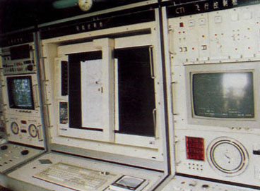
The ground control station of the ASN-105 system (Source: Chinese Internet).
ASN-105型系统的地面控制站(来源:中国英特网)
The ASN-105 has an integrated radio tracking/remote-controlling system which can perform the tracking and controlling of the UAVs. The system is fully computerised. The UAV can fly according to the pre-programmed autopilot, and can be switched into remote-controlling mode at any stage of the flight. The system can be assisted by a tripod-mounted signal relay system, which can be carried by crewmembers in the mountain regions to receive and re-send the image signals.
ASN-105型有一套综合无线电跟踪/遥控系统能执行UAV跟踪和控制。系统完全用计算机处理。UAV能依照预编程自动驾驶仪飞行,并能在飞行任何阶段转入遥控模式。系统能被三脚架安装的信号中继系统辅助,能被成员携带到山区去接收和再传送图像信号。
Specifications
Wingspan: 4.3m
Length: 3.32m
Height: 0.93m
Weight: Max take-off 140kg; Max mission payload 30kg
Speed: Max 250km/h; Cruising 150km/h
Range: 300km
Flight endurance: 2 hours
Service ceiling: 3,200m
Remote control distance: 60km (ASN-104), 100km (ASN-105)
规格
翼展: 4.3 米
机长: 3.32 米
机高: 0.93 米
重量: 最大起飞140 公斤;最大任务负载30 公斤
速度: 最大 250 公里/小时;巡航 150 公里/小时
航程: 300 公里
续飞力: 2 小时
升限: 3,200 米
遥控距离: 60 公里(ASN-104),100 公里(ASN-105)
Last update: 1 February 2009
最后更新: 2009年2月1日
上一篇:ASN-15 Unmanned Reconnaissance Aerial Vehicle 下一篇:ASN-206/207 Unmanned Reconnaissance Aerial Vehicle
| Sea Cavalry SD-40 Maritime UAV
中国海上骑兵SD-40海上无人机 |
| Sea Cavalry SD-40 is a vertical take-off and landing (VTOL) unmanned aerial vehicle (UAV) designed and manufactured by Chinese manufacturer Xiamen Hanfeiying Aviation Technologies.... [2023-05-25] |
| Harbin BZK-005
中国哈尔滨BZK-005型高空长航时无人机 |
| The BZK-005 high-altitude, long-range UAV is a reconnaissance aircraft designed by Beijing University of Aeronautics & Astronautics and Harbin Aircraft Industry (Group) Co., Ltd.... [2017-06-25] |
| Wing Loong Unmanned Aerial Vehicle (UAV), China
中国翼龙(Wing Loong)无人机 |
| Wing Loong (Yilong / Pterodactyl) is a medium-altitude, long-endurance (MALE), unmanned aerial vehicle (UAV) developed by Chengdu Aircraft Design & Research Institute (CADI), a division of the Aviation Industry Corporation of China (AVIC).... [2016-02-18] |
| Xianglong Unmanned Reconnaissance Aerial Vehicle
中国“翔龙”无人侦察机 |
| During the Air Show China 2006, the Chengdu Aircraft Corporation (CAC) unveiled the model of its “Xianglong” unmanned aerial vehicle (UAV) concept. The UAV appeared to be a high-altitude, long-duration UAV for strategic reconnaissance ro... [2010-02-22] |