| BAE Systems’ Azalea satellite cluster streamlines ISR obtention
BAE系统公司的“杜鹃花”卫星集群简化了ISR的获取 Date:2023-06-10 Source:airforce-technology By:John Hill Viewed: |
June 9, 2023
By John Hill
2023年6月9日
约翰·希尔

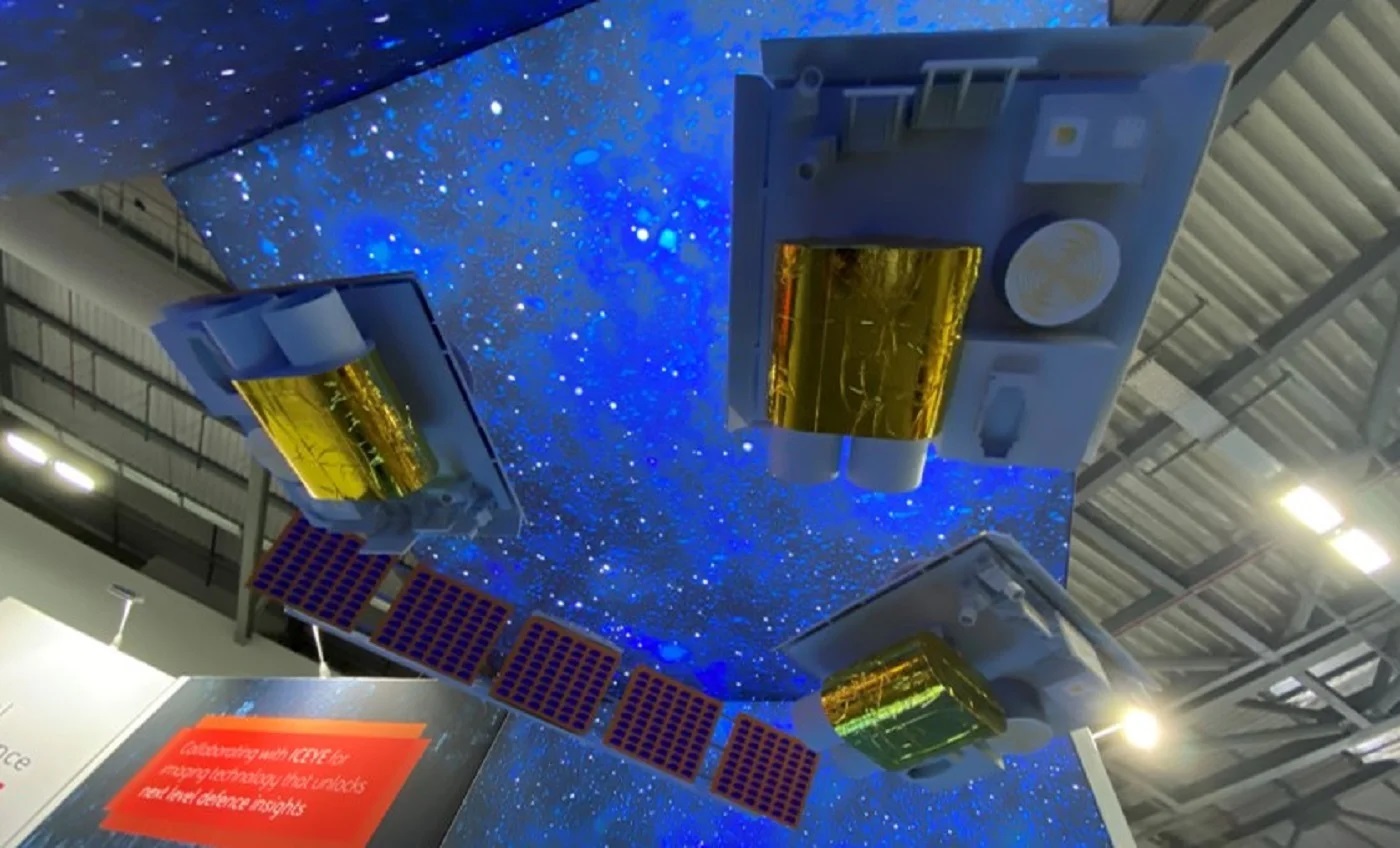
Pictured is a model of the four satellites comprised in the Azalea cluster, which BAE Systems showcased at the Space-Comm Expo, 7-8 June 2023. Credit: John Hill / Airforce Technology.
图为英国宇航系统公司在2023年6月7日至8日的太空通信博览会上展示的“杜鹃花”集群中的四颗卫星的模型。资料来源:约翰·希尔/空军科技公司。
BAE Systems Digital Intelligence has come up with a versatile solution that streamlines the obtention of intelligence, surveillance and reconnaissance (ISR) data.
BAE系统数字情报公司提出了一种多功能的解决方案,可以简化情报、监视和侦察(ISR)数据的获取。
Known as “Azalea”, a cluster of four multi-sensor satellites collect optical, radar and radio frequency (RF) data that is then analysed in orbit using machine learning (ML).
被称为“杜鹃花”的四颗多传感器卫星集群收集光学、雷达和射频(RF)数据,然后使用机器学习(ML)在轨道上进行分析。
Azalea is the result of 25 years of space experience, with the company drawing on its telemetry tracking control processing – which provides the connection between a satellite and its ground-based facilities – for the European Space Agency (ESA).
“杜鹃花”是25年太空经验的结果,该公司利用了对欧洲航天局(ESA)的遥测跟踪控制处理——它提供了卫星与其地面设施之间的连接。
Unlike conventional, single-purpose satellites, the cluster can be fully reconfigured whilst in orbit in the same way a smartphone installs a new app. This delivers versatile capabilities for missions and expands the lifecycle of the satellites.
与传统的单一用途卫星不同,该集群可以在轨道上完全重新配置,就像智能手机安装一个新的应用程序一样。这提供了多功能的任务能力,并扩展了卫星的生命周期。
Initially planned to launch into space in 2024, the high demand for launches has moved this to early 2025.
最初计划于2024年发射到太空,但由于对发射的高需求,这一计划已推迟到2025年初。
The programme supports the UK government’s Defence Space Strategy, published last year, which named Earth observation as a priority area to help protect and defend UK interests.
该计划支持英国政府去年发布的《国防太空战略》,该战略将地球观测列为帮助保护和捍卫英国利益的优先领域。
Showcasing the concept at Space-Comm, John Young, head of strategic campaigns, told Airforce Technology about how this solution offers military intelligence services critical insight into adversarial activity with little to no additional support.
战略战役负责人约翰·杨在太空通信网站上展示了这一概念,他告诉空军技术公司,这一解决方案如何在几乎没有额外支持的情况下为军事情报部门提供对抗性活动的关键见解。

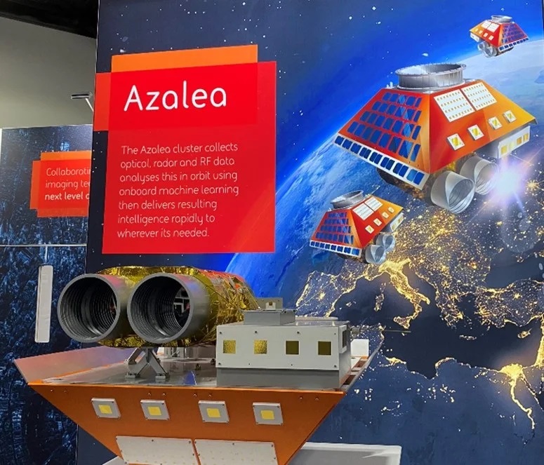
Pictured is a model of a satellite in the Azalea cluster. Credit: John Hill / Airforce Technology.
图为“杜鹃花”星系团中的一颗卫星的模型。资料来源:约翰·希尔/空军技术公司。
Azalea multi-sensors
“杜鹃花”多传感器
“At the moment most people fire one satellite, it does one thing and delivers a load of data, and the reason we’re going for four is that it’s multi-centre.“
“目前大多数人发射一颗卫星,它做一件事,提供大量数据,我们发射四颗卫星的原因是它是多中心的。”
“So you’ve got a satellite; you’ve got optical; you’ve got RF; you’ve got near infrared and you’ve got lots of things on there, but the important part is the payload, so suddenly you start putting in a software defined payload.”
“所以你有一颗卫星;你有光学;你有射频;你有近红外,你有很多东西,但重要的是有效载荷,所以突然你开始加入一个软件定义的有效载荷。”
Interpreting data
解释数据
Many in the space industry expect artificial intellligence to be a major disruptor in the future. But already, BAE Systems has adapted ML to Azalea in order to process ISR data.
许多航天工业人士预计,人工智能将成为未来的主要干扰者。但是,BAE系统公司已经将机器学习(ML)调整到“杜鹃花”中,以处理ISR数据。
“So you’re going from collect to decide using ML techniques and that’s absolutely fundamental.“
“因此,您将使用ML技术从收集到决定,这是绝对基本的。”
“Say that we can see a tank, instead of sending that data down now and having an analyst filter through it until they find the tank, we can get SAR [synthetic aperture radar] to trigger an optical picture of that tank; or an RF; or a near infrared image of that tank; or we can take an RF picture of the environment to see what radio frequencies have been used.
“假设我们可以看到一辆坦克,我们可以让合成孔径雷达触发该坦克的光学图像;或者射频;或者该坦克的近红外图像;或者我们可以拍摄环境的射频图像,看看使用了什么射频。”
“Now when the analyst gets the load of data on the ground, our image can see a tank. They can see it in near infraredness. The analyst will think ‘that’s cold – it’s not going anywhere and there’s no RS signature’. They then know that they don’t need to do anything.”
“现在,当分析师得到地面上的数据负荷时,我们的图像可以看到一个坦克。他们可以在近红外线上看到它。这位分析师会认为“这很冷——不会发生,也没有RS签名”。然后他们就知道他们不需要做任何事情。”
Interstate links
州际链接
The interstate links are an important feature that makes the Azalea different from other military satellite communications (MILSATCOM). This connects the four different satellites.
州际链接是一个重要的特点,使“杜鹃花”不同于其他“军事卫星通信”(MILSATCOM)。这就连接起了四颗不同的卫星。
Young explains the significance of this infrastructure in a hypothetical situation:
杨解释了,在一个假设的情况下,这个基础设施的重要性:
“If you’ve got an urgent mission, you can reprogramme all of [the satellites]” to determine whether to send all of the data or just an alert to investigate.
“如果你有一个紧急任务,你可以重新规划所有的卫星”,以决定是发送所有的数据,还是只是发出警报来进行调查。
“Say, if I see a fishing vessel in this location that looks like it’s low in the water, not only do I send the data back to earth, but I send it via GEO [geostationary orbit]. So I send data and that goes out to the coast guard that says go to this location and investigate.“
“比如,如果我在这个地方看到一艘渔船看起来很低,我不仅要把数据送回地球,还要通过地球静止轨道发送。所以我把数据发送给海岸警卫队,他们说去这个地方进行调查。”
“So the Coast Guard goes in the knowledge that it will get the back information for it.”
“因此,海岸警卫队知道,它将得到相关的反馈信息。”
上一篇:Data centric US Army looks to wearable devices for new edge 下一篇:France’s SCALP missiles long-range weapon for Ukraine’s Armory
| Here are the bunker-buster bombs used on Iran’s Fordo nuclear facility
这是用于伊朗福尔多核设施的碉堡炸弹 |
| In inserting itself into Israel’s war against Iran, the U.S. unleashed its massive “bunker-buster” bombs on Iran’s Fordo fuel enrichment plant.... [2025-07-05] |
| Ukraine's new F-16s receive secret US electronic warfare systems to counter Russi
乌克兰新获的F-16战斗机接收了美国的秘密电子战系统,以应对俄罗斯的威胁 |
| The electronic warfare systems on these Ukrainian F-16s were not part of the U.S. inventory, presenting a significant challenge for the 68th Electronic Warfare Squadron.... [2024-08-28] |
| No U.S. Navy Aircraft Carriers Deployed In The Pacific
美国海军没有在太平洋部署航母 |
| The U.S. Navy is facing a shortfall of deployed carriers in the Pacific as the buildup in the Middle East continues. ... [2024-08-27] |
| France and Serbia Successfully Conclude Negotiations for Sale of 12 Rafale Fighte
法国和塞尔维亚成功完成12架阵风战斗机的销售谈判 |
| Dassault Aviation has successfully concluded negotiations for the sale of 12 Rafale fighter jets to Serbia, marking a significant advancement in bilateral relations between France and Serbia, as reported by LaTribune.... [2024-08-27] |
