| New GEOINT fusion analysis tool could play role in ABMS, JADC2 systems
简氏:新的GEOINT融合分析工具可以在ABMS,JADC2系统中发挥作用 Date:2020-11-02 Source:Jane's By:Globalmil Viewed: |
30 OCTOBER 2020
by Carlo Munoz
2020年10月30日
卡罗·穆诺兹

New geospatial intelligence (GEOINT) fusion analysis software, designed to leverage artificial intelligence (AI) and machine learning (ML) technologies in the management of multisourced big data streams, could find a role in a pair of the US armed forces’ premiere multidomain command-and-control initiative.
新的地理空间智能(GEOINT)融合分析软件,旨在利用人工智能(AI)和机器学习(ML)技术来管理多源大数据流,可能会在美国武装部队首屈一指的多领域指挥和控制计划中找到一个角色。
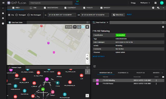
The new GPX Fusion software developed by BAE Systems is squarely focused on helping GEOINT analysts navigate the ever-increasing stream of raw data gathered by intelligence, surveillance, and reconnaissance (ISR) satellites operating at geosynchronous orbit.
由BAE Systems公司开发的新GPX Fusion软件完全致力于帮助GEOINT分析员由地球同步轨道上运行的情报,监视和侦察(ISR)卫星收集的不断增加的原始数据流进行导航。
Under development for the last two and-a-half years, GPX Fusion “is really centred around how ... to solve some of our customer’s big data challenges” by enabling end users to “essentially consume and visualise” not just GEOINT data but also non-imagery based intelligence data not previously possible, said Damon Brady, senior director of product development at BAE Systems’ Advanced GEOINT Systems.
在过去的两年半中,GPX Fusion处于开发过程中,“它的真正重点是通过……使最终用户不仅可以“消费和可视化” GEOINT数据,而且还可以“可视化……解决客户的一些大数据挑战”。 BAE Systems公司的Advanced GEOINT Systems产品开发高级总监达蒙·布雷迪(Damon Brady)说,这也是以前基于非图像的情报数据所无法实现的。
The GPX software leverages graph database capabilities and natural language processing technologies “so that we can really go and consume any information and visualise any information” that is inputted into the GXP Xplorer analysis platform, Brady said on 20 October. “That allows [end users] to unlock new insights; we can find new patterns and new relationships across multisource data [sets],” he added.
布雷迪于10月20日表示,GPX软件利用图形数据库功能和自然语言处理技术“使我们能够真正进入并消费任何信息并可视化任何信息”,这些信息已输入到GXP Xplorer分析平台中。 “这使[最终用户]能够获得新的见解; 我们可以找到跨多源数据[集]的新模式和新关系。”他补充说。
The networked graph database capability allows end users to “sort through the clutter through a set of dynamic filters ... and hone in on specific pieces of data, check the data for the specific relationships between them and then identify new things or create new linkages” to inform improved situational awareness or develop actionable intelligence, Brady said. “That graph [database] tool is really helping to quickly identify and allow the adjudication of some of these relationships” that could not be as easily visualised before, he added.
联网的图形数据库功能允许最终用户“通过一组动态过滤器对混乱进行分类……并细化特定的数据,检查数据之间的特定关系,然后识别新事物或创建新链接。 布雷迪说:“这有助于提高态势感知能力或开发可操作的情报。 他补充说:“该图现[数据库]工具确实有助于快速识别并允许对其中某些关系进行判定”,这是以前很难想象的。
上一篇:China enacts new defence export legislation 下一篇:Pentagon issues new electromagnetic spectrum strategy
| Rheinmetall prepares to turn out first F-35 fuselages
简氏:莱茵金属公司准备生产首批F-35机身 |
| Rheinmetall is to build F-35 fuselages at new Weeze facility in Germany... [2025-07-09] |
| China progresses flight deck operations on third aircraft carrier
简氏:中国在第三艘航母上推进飞行甲板作业 |
| China has begun flight deck operations on its third aircraft carrier Fujian ahead of the vessel's expected commissioning.... [2025-07-09] |
| China challenges US Pacific control with first dual aircraft carrier operation
中国首次使用双航母行动挑战美国对太平洋的控制 |
| As reported by Newsweek on June 10, 2025, for the first time, two Chinese aircraft carriers, CNS Liaoning and CNS Shandong, operated simultaneously beyond the Second Island Chain in the Western Pacific.... [2025-06-11] |
| New imagery of China's KJ-3000 reveals key features
简氏:中国KJ-3000的新图像揭示了关键特征 |
| A KJ-3000 prototype, numbered 7821, has been conducting flight tests since late 2024.... [2025-06-11] |
